Unique challenges and opportunities for Earth Observation in Rwanda
Unique challenges and opportunities for Earth Observation in Rwanda
29 February, 2024 •When I travelled the windy road from Kigali to the Volcanoes National Park to hike up Mount Bisoke, I spent most of my time looking out the window in awe at the scenery. The countryside is plotted and pieced together by thousands of fields of different crops. It is not only beautiful; these plots represent a livelihood for millions of smallholder farmers in Rwanda.
Despite the reliance on agriculture, it is difficult for agricultural authorities in Rwanda to understand how much land has been cultivated or what crops have been planted. They want to keep track of progression across each season and monitor the growth stages of different crops. One potential tool to answer some of these questions lies with Earth Observation (EO).
Satellite images have been used for decades in many applications, including agriculture, and the question was, could it be successful in the local Rwandan context? As part of the Rwanda Economy Digitalisation programme, a colleague and I worked closely with the Rwanda Space Agency (RSA) to analyse data and test whether satellite images could be used to identify underperforming fields. We found some promising results.
Our analysis focused on a small area of the country, comprising just over 6,000 plots, where only maize was grown. Three years of satellite images were processed by the RSA to produce Normalised Difference Vegetation Indexes (NDVI) for each plot at weekly intervals. NDVI, broadly, is a measure of the amount and vigour of vegetation on the land’s surface.
We used this as a proxy for growth and plant health and the data allowed us to see the patterns of cultivation, growth and harvesting for each season. NDVI measurements tracked these stages and correlated with rainfall patterns.
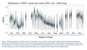
At a disaggregated level we were able to track NDVI values for each parcel of land and analyse the aggregated distributions, as shown in Figure 1. This was powerful because it allowed us to identify individual outliers within those distributions because, theoretically, farmers who planted the same crops in the same area should all have exhibited similar trends across the season.
Consequently, plots with the least change in NDVI over the growing stages or those that did not reach the peaks seen by other farmers could be experiencing issues and need some assistance. From the point of view of the agricultural authorities (or related government ministries) Identifying those parcels of land is the first step in mitigating potential productivity losses.
Through our analysis we were able to identify these outliers so that policymakers could understand the efficacy of their agricultural input subsidy schemes and improve food security. They need an idea of how much food the country is going to produce and a way to track the season’s progress. Monitoring fields from satellite images would allow them to do this. Although our analysis was an important step towards a data-driven smart agriculture approach to public policy, there are aspects that still need to be refined. Our analytical strength lies in transforming data into insights for policy decisions.
The time spent working with RSA taught us some valuable lessons about Earth Observation and the challenges we faced. Firstly, we measured NDVI per plot, not per field. Sometimes a field only makes up 50% of the plot with the rest of the plot taken up with a building or fallow land. Since the NDVI values of buildings don’t change over the season our measurement has less variation across the season than it should. For this reason, field boundary delineation is a vital first step and a key area of future collaboration with the RSA. Successful implementation would mean accurately identifying each field boundary to focus the analysis and produce more reliable NDVI values.
Secondly, our findings are not generalisable across crop types at this stage. Each crop type will have different trends over the season. For a nationwide analysis, we would have to separately analyse each crop type, which would require accurately identifying them. Having a robust crop type classification, built on accurate field boundary delineation, is required.
Thirdly, NDVI measurements are adversely affected by cloud cover. During the rainy season, when crops are growing the most, the region has extensive cloud cover resulting in unusable satellite images. This means that alternative means of measuring crop growth are required, such as Synthetic Aperture Radar satellites, which the RSA has identified as a potential solution to this problem going forward.
Fortunately, these challenges are not unique. Other regions have tightly packed crop fields and experience cloud cover as well. What is required is the expertise, with the right infrastructure, to execute the technical requirements. Going forward we see a need for a robust system to perform field-boundary delineation and crop type mapping. This will allow for more reliable and generalisable findings.
External validation is also required, the findings need to be verified and fields physically inspected. In addition to the technical challenges, policy insights need to be derived from the data analysis. It requires the ‘technical and policy silos’ to work together to develop solutions that are practical, reliable and can be implemented. This is a key goal of future collaboration with the RSA.
When I finally reached the summit of Mount Bisoke there was a thick cloud of mist obscuring the view of Crater Lake. I was initially disappointed as the view was meant to be my reward for hours of toil through the jungle forest. But when the mist finally cleared, I understood why this was such a popular tourist destination, and that from a great height you can see a great many things.
If you are interested in learning more about our work in Rwanda, you can contact Arlette Rwakazina.